Dencukaay:Zurich area topographic map-fr.jpg

Le contenu de la page n’est pas pris en charge dans d’autres langues.
Jóge Wikipedia.

réyal nataal bi((1 610 × 1 360 pixels, réyaayu file bi : 932 kio, type MIME : image/jpeg))

Dencukaay bii Wikimedia Commons la bàyyikoo te man nañu koo jëfandikoo ci yeneen sémb. Faramfacce gi ci xëtu faramfaccewaayu xët wi lañuy wone ci suuf .

Faramfacce

Lieu de la prise de vue47° 22′ 40″ N, 8° 32′ 28″ E Kartographer map based on OpenStreetMap.Voir cet endroit et d’autres images sur : OpenStreetMapinfo


Faramfacce
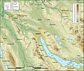
English: Topographic map in French of the area of Zürich, Switzerland
Note : for translation purpose, use the SVG version.
Français : Carte topographique en français de la région de Zurich, Suisse
Taariix
Gongikuwaay
English: Own work (see complete description on Image:Zurich_area_topographic_map-fr.svg)
Approximate scale of the topographic data : 1:372,000 (accuracy : about 93 m).
Note : The limit of the urbanized areas is approximate, particularly when several cities are close one of the other.

Français : Création personnelle (voir description complète sur Image:Zurich_area_topographic_map-fr.svg)
Échelle approximative des données topographiques : 1:372 000 (précision : environ 93 m).
Note : La limite des zones urbaines est approximative, en particulier aux endroits où plusieurs agglomérations se touchent.

Approximate geographic limits of the map (3" close) :
* SW corner : 47° 10' 40" N – 08° 12' 40" E
* SE corner : 47° 10' 40" N – 08° 53' 00" E
* NE corner : 47° 33' 55" N – 08° 53' 08" E
* NW corner : 47° 33' 55" N – 08° 12' 32" E
Aji-jëf Eric Gaba (Sting - fr:Sting)
Sañal
(Njëfandikoowaatu bii dencukaay)
Attribution and Share-Alike required
Autres versions

[soppi]

Anami Jëfandikoo gi

Moi, en tant que détenteur des droits d’auteur sur cette œuvre, je la publie sous les licences suivantes :
GNU head Sañalees na duppi, séddale ak/walla soppi bile liggéey ci anami GNU Free Documentation License, Sumb 1.2 walla bépp sumb buFree Software Foundation mujjee siiwal; bu amul benn pàcc bees manul soppi, te amul it menn mbind ci xët wu njëkk week wu mujj wi. Ab sotti bu sañal gi jàppandi na ci pàcc bees duppee GNU Free Documentation License.
w:fr:Creative Commons
Moomale Séeddoo ci gii anamam
This file is licensed under the Creative Commons Attribution-Share Alike 4.0 International, 3.0 Unported, 2.5 Generic, 2.0 Generic and 1.0 Generic license.
Féeg nga ci:
  • séddoo – duppi, séddale ak yónnee bile liggéey.
  • soppi – soppi liggéey bi
Ci kaw yii anam:
  • Moomale – Fàww nga joxe ay xibaar yu leer ñeel boroom, joxe ab lëkkalekaay buy jëme ci sañal gi te wax ndax def nga ciy coppite. Man nga koo def ci anam yu bari, ba mu des ci guy wund ne aji-moom ji dafa ànd ak yaw walla ànd na ci ninga koy jëfandikoo)
  • Séeddoo ci gii anamam – Soo soppee walla nga defar leneen te sukkadiku ci bii liggéey, faww nga siiwal ko ci genn sañal gi walla geneen gum méngool
.
Man ngaa tànn sañale gi la gënal.

Légendes

Ajoutez en une ligne la description de ce que représente ce fichier

Éléments décrits dans ce fichier

dépeint Farañse

47°22'40.001"N, 8°32'28.000"E

Jaar-jaaru dencukaay bi

Cuqal cib taariix/waxtu ngir gis ni dencukaay bi meloon ca jamono jooju.

Taariix ak WaxtuTuutalDayooJëfandikukatSaraa
teew17 Sulet 2010 à 21:28Tuutal gu sumb bu 17 Sulet 2010 à 21:281 610 × 1 360 (932 kio)StingColor profile
4 Sattumbar 2008 à 16:29Tuutal gu sumb bu 4 Sattumbar 2008 à 16:291 610 × 1 360 (865 kio)StingNew standard colors
19 Maars 2008 à 05:03Tuutal gu sumb bu 19 Maars 2008 à 05:031 610 × 1 360 (967 kio)Sting{{Location|47|22|40|N|08|32|28|E|scale:200000}} <br/> {{Information |Description={{en|Topographic map in French of the area of Zürich, Switzerland<br/>''Note :'' for translation purpose, use the [[:Image:Zurich_area_to

Xët wii ci suuf ëmb na wii ŋara

Fépp fees jëfandikoo dencukaay bi

Yeneen wiki yiy toftal dañuy jëfandikoo itam bii dencukaay:

  • Jëfandikoo nañu ko ci bn.wikipedia.org
  • Jëfandikoo nañu ko ci fr.wikipedia.org

Jégginjoxe