
Dencukaay:People's Republic of China (orthographic projection).svg

Taille de cet aperçu PNG pour ce fichier SVG : 541 × 541 pixel. Yeneen ñawaay: 240 × 240 pixel • 480 × 480 pixel • 768 × 768 pixel • 1 024 × 1 024 pixel • 2 048 × 2 048 pixel.
réyal nataal bi (Dencukaay SVG, kem bu jaadu 541 × 541 pixel, dayoo dencukaay bi: 260 kio)
Faramfacce
| Faramfacce |
Italiano: La Repubblica Popolare Cinese (in verde) e il territorio da essa dichiarato (in verde chiaro).
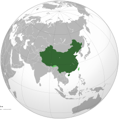
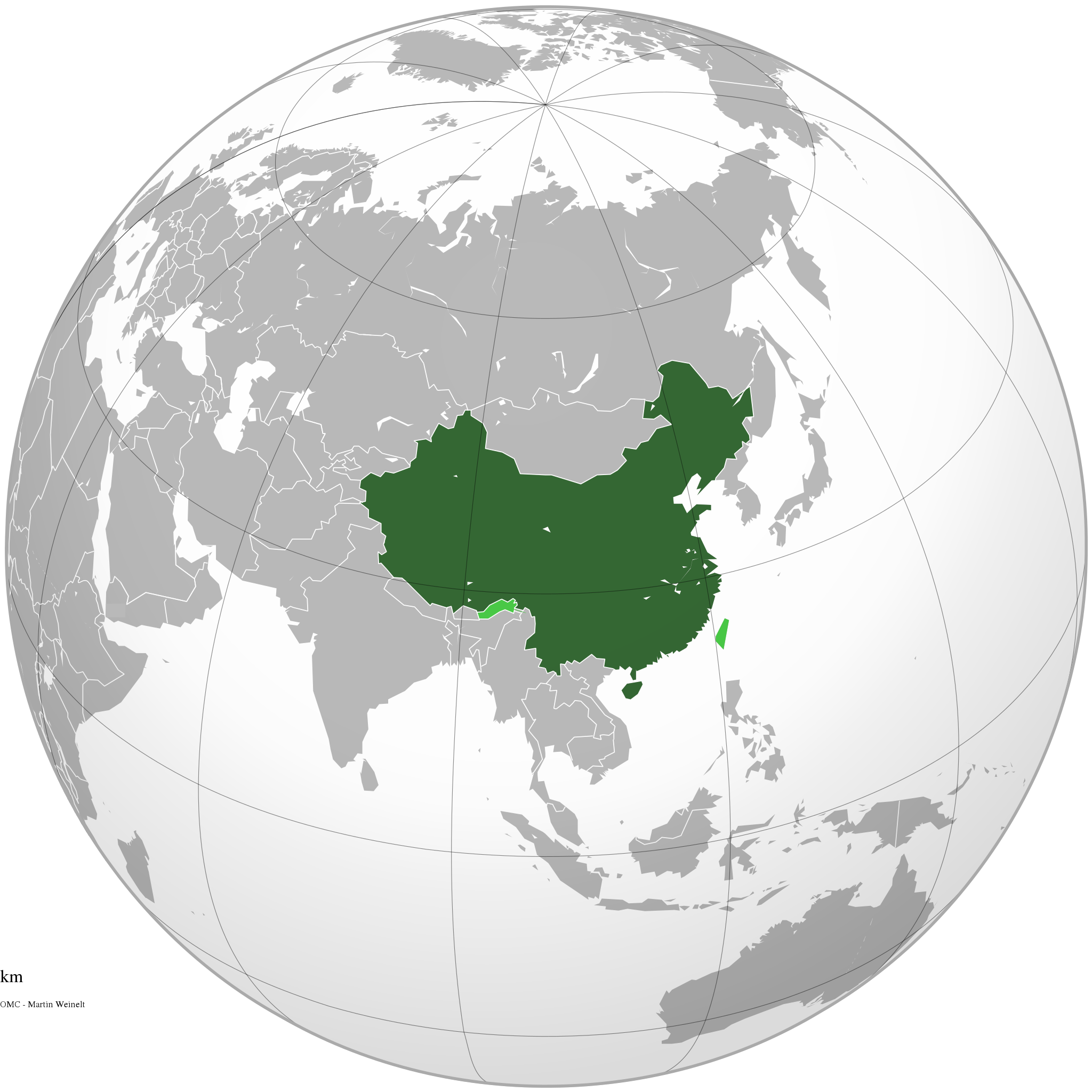
English: The People's Republic of China (green) and its claimed territory (lighter green).
Русский: Китайская Народная Республика (зелёный).
Українська: Територія Китаю позначена зеленим. Територія, на яку претендує Китай, але не контролює її, позначена світло-зеленим.
中文(简体):中华人民共和国(深绿色)及其认为拥有主权的地区(浅绿色)。
中文(繁體):中華人民共和國(深綠色)及其自認為擁有主權的地區(淺綠色)。 |
||||
| Taariix | |||||
| Gongikuwaay |
Sama liggéey (Original text: Own work)
|
||||
| Aji-jëf | Ssolbergj | ||||
| Autres versions |
.svg)
|
||||
| SVG information |
.jpg)
.svg)
.svg)
.svg)
.svg)
.svg)
.svg)
.svg)
.svg)
.svg)
.svg)
.svg)
.svg)
.svg)
.svg)
.svg)
.svg)
.svg)
.svg)
.svg)
.svg)
.svg)
.svg)
.svg)
.svg)
.svg)
.svg)
.svg)
.svg)
.svg)
.svg)
.svg)
.svg)
.svg)
.svg)
.svg)
.svg)
.svg)
.svg)
.svg)
.svg)
.svg)
.svg)
.svg)
.svg)
.svg)
.svg)
.svg)
.svg)
.svg)
.svg)
.svg)
.svg)
.svg)
.svg)
.svg)
.svg)
.svg)
.svg)
.svg)
.svg)
.svg)
.svg)
.svg)
.svg)
.svg)
.svg)
.svg)
.svg)
.svg)
.svg)
.svg)
.svg)
.svg)

.svg)

.svg)

.svg)
.svg)
.svg)
.svg)
.svg)
.svg)
.svg)


.svg)
.svg)
.svg)
.svg)
.svg)
.svg)
.svg)

.svg)
.svg)
.svg)
.svg)
.svg)
.svg)
.svg)
.svg)
.svg)

.svg)
.svg)
.svg)
.svg)
.svg)
.svg)
.svg)
_without_national_boundaries.svg)
.svg)
.svg)
.svg)
.svg)
.svg)
.svg)

.svg)
.svg)
.png)
.svg)
.svg)
.svg)
.svg)

.svg)
.svg)
.svg)
.svg)
.svg)
.svg)
.svg)
.svg)
.svg)
.svg)
.svg)

.svg)
.svg)
.svg)
.svg)
.svg)
.svg)
.svg)
.svg)
.svg)

.svg)
.svg)

.svg)
.svg)
.svg)
.svg)
.svg)
.svg)
.svg)
.svg)
.svg)
.svg)
.svg)
.svg)
.svg)
.svg)
.svg)
.svg)
.svg)
.svg)
.svg)
.svg)
.svg)
.svg)
.svg)
.svg)
.svg)
.svg)
.svg)
_-_Crimea_disputed.svg)
.svg)
.svg)
.svg)
.svg)
.svg)
.svg)
.svg)
.svg)
.svg)
.svg)
.svg)
_political.svg)
.svg)
.svg)
.svg)
.svg)
_-_Crimea_disputed_-_no_borders.svg)
.svg)
.svg)
.svg)
.svg)
.svg)
.svg)
.svg)
.svg)
.svg)
.svg)
.svg)

.svg)
.svg)
.svg)

.png)
.svg)
.svg)
.svg)
.svg)
.svg)
.svg)
.svg)
.svg)
.svg)
.svg)
.svg)
.svg)
.svg)
.svg)
.svg)
.svg)
.svg)
.svg)
.svg)
.svg)
.svg)
.svg)
.svg)
.svg)
.svg)
.svg)
.svg)
.svg)
.svg)
.svg)
.svg)
.svg)
.svg)
.svg)
.png)
.svg)
.svg)
.svg)
_(orthographic_projection).png)
.svg)
.svg)
.svg)
Anami Jëfandikoo gi
Moi, en tant que détenteur des droits d’auteur sur cette œuvre, je la publie sous les licences suivantes :

|
Sañalees na duppi, séddale ak/walla soppi bile liggéey ci anami GNU Free Documentation License, Sumb 1.2 walla bépp sumb buFree Software Foundation mujjee siiwal; bu amul benn pàcc bees manul soppi, te amul it menn mbind ci xët wu njëkk week wu mujj wi. Ab sotti bu sañal gi jàppandi na ci pàcc bees duppee GNU Free Documentation License. |
This file is licensed under the Creative Commons Attribution-Share Alike 4.0 International, 3.0 Unported, 2.5 Generic, 2.0 Generic and 1.0 Generic license.
- Féeg nga ci:
- séddoo – duppi, séddale ak yónnee bile liggéey.
- soppi – soppi liggéey bi
- Ci kaw yii anam:
- Moomale – Fàww nga joxe ay xibaar yu leer ñeel boroom, joxe ab lëkkalekaay buy jëme ci sañal gi te wax ndax def nga ciy coppite. Man nga koo def ci anam yu bari, ba mu des ci guy wund ne aji-moom ji dafa ànd ak yaw walla ànd na ci ninga koy jëfandikoo)
- Séeddoo ci gii anamam – Soo soppee walla nga defar leneen te sukkadiku ci bii liggéey, faww nga siiwal ko ci genn sañal gi walla geneen gum méngool
Man ngaa tànn sañale gi la gënal.
Jaar-jaaru dencukaay bi
Cuqal cib taariix/waxtu ngir gis ni dencukaay bi meloon ca jamono jooju.
.svg&dir=prev)
.svg&offset=20111111220409)
.svg&offset=&limit=20)
.svg&offset=&limit=50)
.svg&offset=&limit=100)
.svg&offset=&limit=250)
.svg&offset=&limit=500)
| Taariix ak Waxtu | Tuutal | Dayoo | Jëfandikukat | Saraa | |
|---|---|---|---|---|---|
| teew | 29 Disembar 2019 à 15:16 | | 541 × 541 (260 kio) | Goran tek-en | Added border for South Sudan as requested by Maphobbyist |
| 25 Awril 2014 à 06:05 |  | 541 × 541 (142 kio) | Chipmunkdavis | Rv removal of claimed territories | |
| 23 Awril 2014 à 16:05 |  | 541 × 541 (498 kio) | Lawson123 | Reverted to version as of 17:14, 15 March 2014 | |
| 15 Maars 2014 à 19:13 |  | 541 × 541 (142 kio) | Chipmunkdavis | Rv removal of claimed territories | |
| 15 Maars 2014 à 17:14 |  | 541 × 541 (498 kio) | Semidwarf | Reverted to version as of 20:49, 14 March 2014 | |
| 15 Maars 2014 à 00:14 |  | 541 × 541 (142 kio) | Chipmunkdavis | Rv removal of claimed territories | |
| 14 Maars 2014 à 20:49 |  | 541 × 541 (498 kio) | Semidwarf | Reverted to version as of 14:49, 9 April 2011 | |
| 14 Maars 2014 à 20:48 |  | 541 × 541 (498 kio) | Semidwarf | Reverted to version as of 14:49, 9 April 2011 | |
| 12 Sattumbar 2012 à 21:53 |  | 541 × 541 (142 kio) | Palosirkka | Scrubbed with http://codedread.com/scour/ | |
| 11 Nowembar 2011 à 22:04 |  | 541 × 541 (481 kio) | Gucong | According to http://en.wikipedia.org/wiki/Wikipedia:WikiProject_Maps/Conventions/Orthographic_maps , claimed areas shall be marked as light green |
Xët yi am wii ŋara
Amul wenn xët wuy jëfandikoo bii dencukaay.
Fépp fees jëfandikoo dencukaay bi
Yeneen wiki yiy toftal dañuy jëfandikoo itam bii dencukaay:
- Jëfandikoo nañu ko ci af.wikipedia.org
- Jëfandikoo nañu ko ci ami.wikipedia.org
- Jëfandikoo nañu ko ci arc.wikipedia.org
- Jëfandikoo nañu ko ci ar.wikipedia.org
- Jëfandikoo nañu ko ci as.wikipedia.org
- Jëfandikoo nañu ko ci av.wikipedia.org
- Jëfandikoo nañu ko ci azb.wikipedia.org
- Jëfandikoo nañu ko ci az.wikipedia.org
- Jëfandikoo nañu ko ci az.wiktionary.org
- Jëfandikoo nañu ko ci ban.wikipedia.org
- Jëfandikoo nañu ko ci ba.wikipedia.org
- Jëfandikoo nañu ko ci bcl.wikipedia.org
- Jëfandikoo nañu ko ci beta.wikiversity.org
- Jëfandikoo nañu ko ci be.wikipedia.org
- Jëfandikoo nañu ko ci bh.wikipedia.org
- Jëfandikoo nañu ko ci bn.wikipedia.org
- Jëfandikoo nañu ko ci cdo.wikipedia.org
- Jëfandikoo nañu ko ci cs.wikipedia.org
- Jëfandikoo nañu ko ci cu.wikipedia.org
- Jëfandikoo nañu ko ci da.wikipedia.org
- Jëfandikoo nañu ko ci de.wiktionary.org
- Jëfandikoo nañu ko ci dty.wikipedia.org
- Jëfandikoo nañu ko ci dz.wikipedia.org
- Jëfandikoo nañu ko ci el.wikipedia.org
- Jëfandikoo nañu ko ci el.wikinews.org
- Το Διεθνές Νομισματικό Ταμείο προειδοποεί τη Κίνα για το γουάν
- Πρότυπο:Κίνα
- Ατύχημα με 41 νεκρούς στη Κίνα
- Κίνα: Η στήριξη της Ελλάδας αποτελεί σημαντικό βήμα για την Ευρωζώνη
- Συνεχίζονται οι απεργίες των ταξί στη Κίνα
- Πενηντατέσσερις αμαξοστοιχίες ανακαλούνται στην Κίνα για λόγους ασφαλείας
- Η Coca-Cola θα επενδύσει 4 δισεκατομμύρια δολάρια στη Κίνα για τα επόμενα 3 έτη
- Διασώθηκαν 19 παγιδευμένοι ανθρακωρύχοι στη Κίνα
- Ήπια ενίσχυση της μεταποίησης στη Κίνα
- Δέκα ανθρακωρύχοι ανασύρθηκαν νεκροί από ορυχείο της Κίνας
- Ανακαλύφθηκε τάφος με 12 άλογα στη Κίνα
- Έντεκα άτομα σκοτώθηκαν σε ναυάγιο στη Κίνα
- Κίνα: Δεκάδες νεκροί και αγνοούμενοι ύστερα από ισχυρές βροχοπτώσεις
- Κρούσματα πολιομυελίτιδας στην Κίνα για πρώτη φορά από το 1999
- Στη Κίνα συνελήφθη άνδρας που βίαζε στο υπόγειο έξι γυναίκες για δύο χρόνια
- Σανγκάη: Εκατοντάδες τραυματίες σε σύγκρουση συρμών του μετρό
- Στην Κίνα ο Βλαντιμίρ Πούτιν
Wone njëfandikoo gu daj gu bii dencukaay.
.svg)
.svg)