
Dencukaay:Africa independence dates.PNG

Dayoob bii wonendi: 564 × 600 pixel. Yeneen ñawaay: 226 × 240 pixel • 451 × 480 pixel • 752 × 800 pixel.
réyal nataal bi ((752 × 800 pixels, réyaayu file bi : 42 kio, type MIME : image/png))

|
Une version vectorielle de cette image existe, dans le format « SVG ». Si elle n’est pas inférieure, elle devrait être utilisée à la place de la présente version pour des affichages en plus grandes dimensions ou nécessitant une meilleure résolution.
File:Africa independence dates.PNG → File:Africa independence dates.svg
Pour plus d’informations sur les images vectorielles, consultez la page de transition de Commons vers le format SVG. Voir aussi les informations à propos de la manière dont le logiciel MediaWiki gère les images au format SVG. |
 |
Faramfacce
Español: Fechas de independencia de los países africanos.
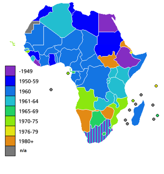
Countries of Africa, with date of independence
Anami Jëfandikoo gi

|
Sañalees na duppi, séddale ak/walla soppi bile liggéey ci anami GNU Free Documentation License, Sumb 1.2 walla bépp sumb buFree Software Foundation mujjee siiwal; bu amul benn pàcc bees manul soppi, te amul it menn mbind ci xët wu njëkk week wu mujj wi. Ab sotti bu sañal gi jàppandi na ci pàcc bees duppee GNU Free Documentation License. |
| Jàppandeeb bii dencukaay a ngi aju ci sañal gu Creative Commons Féetale-Séddoo ci gennug anam 3.0 Unported | ||
. | ||
| Ce bandeau de licence a été ajouté à ce fichier dans le cadre de la procédure de mise à jour des licences des images sous GFDL. |
Jaar-jaaru dencukaay bi
Cuqal cib taariix/waxtu ngir gis ni dencukaay bi meloon ca jamono jooju.
| Taariix ak Waxtu | Tuutal | Dayoo | Jëfandikukat | Saraa | |
|---|---|---|---|---|---|
| teew | 9 Sulet 2011 à 04:25 | | 752 × 800 (42 kio) | Hoshie | added South Sudan to the map |
| 19 Suwe 2011 à 02:34 |  | 752 × 800 (42 kio) | Muso | Reverted to version as of 10:09, 22 April 2011 | |
| 19 Suwe 2011 à 02:19 |  | 752 × 800 (14 kio) | Muso | Zimbabwe got his independence in 1965, therefore correct its color from orange green | |
| 22 Awril 2011 à 10:09 |  | 752 × 800 (42 kio) | Hoshie | added the French departements of Mayotte and Reunion and the Ilies Eparses distict of the TAAF; CIA maps was used as a source. A version w/ Southern Sudan is ready for July. | |
| 11 Awril 2011 à 03:00 |  | 752 × 800 (42 kio) | Hoshie | added Cabinda (Angola) to the map; a version with Southern Sudan is ready once they declare independence in July. | |
| 6 Awril 2010 à 18:16 |  | 752 × 800 (38 kio) | Lemonade100 | De Jure Independance of Zimbawe and South Africa (changed from de facto), St Helena and dependancies added. | |
| 23 Maars 2008 à 01:35 |  | 752 × 690 (36 kio) | Serg!o | UN considers Sahara as a colony - ONU considera Sahara como colonia | |
| 22 Maars 2006 à 11:44 |  | 752 × 690 (36 kio) | Roke~commonswiki | Countries of Africa, with date of independence Category: Maps of Africa Category: History of Africa |
Xët yi am wii ŋara
Amul wenn xët wuy jëfandikoo bii dencukaay.
Fépp fees jëfandikoo dencukaay bi
Yeneen wiki yiy toftal dañuy jëfandikoo itam bii dencukaay:
- Jëfandikoo nañu ko ci bn.wikipedia.org
- Jëfandikoo nañu ko ci el.wikivoyage.org
- Jëfandikoo nañu ko ci en.wikipedia.org
- Jëfandikoo nañu ko ci hi.wikipedia.org