
Dencukaay:Ph physical map.png
Dayoob bii wonendi: 382 × 598 pixel. Yeneen ñawaay: 153 × 240 pixel • 600 × 940 pixel.
réyal nataal bi ((600 × 940 pixels, réyaayu file bi : 114 kio, type MIME : image/png))
Faramfacce
| Faramfacce |
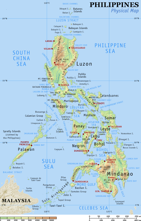
English: Physical map of the Philippines, showing all the major and some minor islands, bodies of water, mountains, and some major cities. |
| Taariix | |
| Gongikuwaay | Sama liggéey |
| Aji-jëf | Eugene Alvin Villar (seav) |
| Autres versions |
|


|

|
Cette image (de type carte) devrait être recréée dans un format vectoriel, en tant que fichier SVG. Cela offrirait plusieurs avantages : voir Commons:Media for cleanup pour plus d'informations. Si une version SVG de cette image est déjà disponible, merci de bien vouloir l'envoyer. Après cela, remplacez ce modèle par {{vector version available|nouveau nom d'image.svg}}.
|
Anami Jëfandikoo gi
Moi, en tant que détenteur des droits d’auteur sur cette œuvre, je la publie sous les licences suivantes :
Ce fichier est sous la licence Creative Commons Attribution – Partage dans les Mêmes Conditions 4.0 International.
- Féeg nga ci:
- séddoo – duppi, séddale ak yónnee bile liggéey.
- soppi – soppi liggéey bi
- Ci kaw yii anam:
- Moomale – Fàww nga joxe ay xibaar yu leer ñeel boroom, joxe ab lëkkalekaay buy jëme ci sañal gi te wax ndax def nga ciy coppite. Man nga koo def ci anam yu bari, ba mu des ci guy wund ne aji-moom ji dafa ànd ak yaw walla ànd na ci ninga koy jëfandikoo)
- Séeddoo ci gii anamam – Soo soppee walla nga defar leneen te sukkadiku ci bii liggéey, faww nga siiwal ko ci genn sañal gi walla geneen gum méngool
Jàppandeeb bii dencukaay a ngi aju ci sañal gu Creative Commons Féetale-Séddoo ci gennug anam 3.0 Unported
- Féeg nga ci:
- séddoo – duppi, séddale ak yónnee bile liggéey.
- soppi – soppi liggéey bi
- Ci kaw yii anam:
- Moomale – Fàww nga joxe ay xibaar yu leer ñeel boroom, joxe ab lëkkalekaay buy jëme ci sañal gi te wax ndax def nga ciy coppite. Man nga koo def ci anam yu bari, ba mu des ci guy wund ne aji-moom ji dafa ànd ak yaw walla ànd na ci ninga koy jëfandikoo)
- Séeddoo ci gii anamam – Soo soppee walla nga defar leneen te sukkadiku ci bii liggéey, faww nga siiwal ko ci genn sañal gi walla geneen gum méngool

|
Sañalees na duppi, séddale ak/walla soppi bile liggéey ci anami GNU Free Documentation License, Sumb 1.2 walla bépp sumb buFree Software Foundation mujjee siiwal; bu amul benn pàcc bees manul soppi, te amul it menn mbind ci xët wu njëkk week wu mujj wi. Ab sotti bu sañal gi jàppandi na ci pàcc bees duppee GNU Free Documentation License. |
Man ngaa tànn sañale gi la gënal.
Journal des téléversements d’origine
The original description page was here. All following user names refer to en.wikipedia.
| Date | User | File size | History log |
|---|---|---|---|
| 2005-08-29 15:09 | Riumplus | (117068 bytes) | Removed unused colours in the PNG palette, losslessly shrinking file size by 4% |
| 2004-07-25 09:09 | Guanaco | (121976 bytes) | optimize |
| 2003-08-17 08:46 | Seav | (122906 bytes) | Updated map with more details |
| 2003-06-20 11:13 | Seav | (130670 bytes) | Physical map of the Philippines. |
Jaar-jaaru dencukaay bi
Cuqal cib taariix/waxtu ngir gis ni dencukaay bi meloon ca jamono jooju.
| Taariix ak Waxtu | Tuutal | Dayoo | Jëfandikukat | Saraa | |
|---|---|---|---|---|---|
| teew | 1 Maars 2007 à 22:05 | | 600 × 940 (114 kio) | Tene~commonswiki | Optimised (0) |
| 16 Sattumbar 2005 à 17:21 |  | 600 × 940 (114 kio) | Saperaud~commonswiki | Physical map of the Philippines, showing all the major and some minor islands, bodies of water, mountains, and some major cities. See blank version which can be used for other language |
Xët yi am wii ŋara
Xët wii ci suuf ëmb na wii ŋara
Fépp fees jëfandikoo dencukaay bi
Yeneen wiki yiy toftal dañuy jëfandikoo itam bii dencukaay:
- Jëfandikoo nañu ko ci af.wikipedia.org
- Jëfandikoo nañu ko ci an.wikipedia.org
- Jëfandikoo nañu ko ci ba.wikipedia.org
- Jëfandikoo nañu ko ci bg.wikipedia.org
- Jëfandikoo nañu ko ci bn.wikipedia.org
- Jëfandikoo nañu ko ci br.wikipedia.org
- Jëfandikoo nañu ko ci ca.wikipedia.org
- Jëfandikoo nañu ko ci cbk-zam.wikipedia.org
- Jëfandikoo nañu ko ci ceb.wikipedia.org
- Jëfandikoo nañu ko ci da.wikipedia.org
- Jëfandikoo nañu ko ci de.wikipedia.org
- Jëfandikoo nañu ko ci en.wikipedia.org
- User:Seav
- List of islands of the Philippines
- Template:Pic of the day/Archive1
- Ecoregions in the Philippines
- Wikipedia:Picture of the day/June 2004
- Manila Trench
- Wikipedia:Picture of the day/April 2005
- Wikipedia:POTD/April 13, 2005
- Wikipedia:Picture of the day/April 13, 2005
- User:Cyde/Featured pictures
- Wikipedia:Featured picture candidates/delist/2006
- Portal:Maps/Selected picture
- User talk:Howard the Duck/Archive3
- Wikipedia:Featured picture candidates/delist/2007
- Island groups of the Philippines
- Wikipedia:Featured picture candidates/delist/Ph physical map.png
- List of potentially active volcanoes in the Philippines
- User:Wittylama/FP Deletion
- Extreme points of the Philippines
- Portal:Maps/Selected picture/1
- Outline of the Philippines
- List of ultras of the Philippines
- List of active volcanoes in the Philippines
- List of inactive volcanoes in the Philippines
- Philippine Mobile Belt
- List of rivers of the Philippines
- Benham Rise
- Philippine Fault System
- List of lighthouses in the Philippines
- Wikipedia:Featured picture candidates/delist/2010
- Marikina Valley Fault System
- Wikipedia:Featured picture candidates/delist/File:Ph physical map.png
- List of mountains in the Philippines
- List of lakes of the Philippines
- List of protected areas of the Philippines
- List of bays of the Philippines
- List of headlands of the Philippines
Wone njëfandikoo gu daj gu bii dencukaay.