
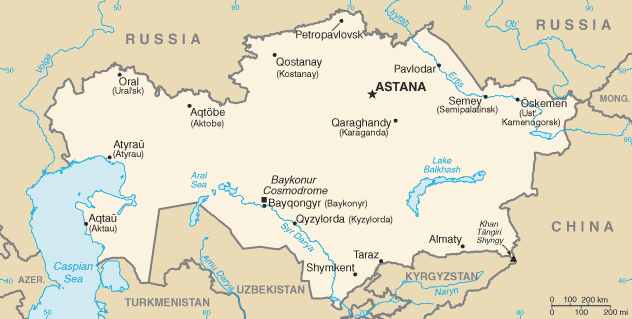
Dencukaay:Kazakhstan-CIA WFB Map.png
Amul kem bu ëpp bii bu jàppandi.
Kazakhstan-CIA_WFB_Map.png ((632 × 319 pixels, réyaayu file bi : 21 kio, type MIME : image/png))

|
Cette image (de type locator map) devrait être recréée dans un format vectoriel, en tant que fichier SVG. Cela offrirait plusieurs avantages : voir Commons:Media for cleanup pour plus d'informations. Si une version SVG de cette image est déjà disponible, merci de bien vouloir l'envoyer. Après cela, remplacez ce modèle par {{vector version available|nouveau nom d'image.svg}}.
|
.png)
Cette image est dans le domaine public parce que son contenu provient du World Factbook, édité par la Central Intelligence Agency des États-Unis d’Amérique.
|
 |
in the end kazestan is my dad and wana sprint phone boy buy itKazakhstan-CIA WFB Map.png
Jaar-jaaru dencukaay bi
Cuqal cib taariix/waxtu ngir gis ni dencukaay bi meloon ca jamono jooju.
| Taariix ak Waxtu | Tuutal | Dayoo | Jëfandikukat | Saraa | |
|---|---|---|---|---|---|
| teew | 19 Fewriyee 2022 à 07:41 | | 632 × 319 (21 kio) | Lojwe | Cropped < 1 % horizontally, 2 % vertically using CropTool with precise mode. |
| 18 Nowembar 2009 à 08:24 |  | 634 × 324 (21 kio) | Kwamikagami | Aral Sea as of 2009 | |
| 16 Ut 2006 à 22:48 |  | 634 × 324 (21 kio) | Aivazovsky~commonswiki | Fixing map to match present version on the CIA World Factbook site. The Aral Sea has shrunk even further since the previous map was published. | |
| 27 Maars 2005 à 09:15 |  | 659 × 338 (25 kio) | Wolfman~commonswiki | {{CIA-map}} |
Xët yi am wii ŋara
Xët wii ci suuf ëmb na wii ŋara
Fépp fees jëfandikoo dencukaay bi
Yeneen wiki yiy toftal dañuy jëfandikoo itam bii dencukaay:
- Jëfandikoo nañu ko ci af.wikipedia.org
- Jëfandikoo nañu ko ci as.wikipedia.org
- Jëfandikoo nañu ko ci azb.wikipedia.org
- Jëfandikoo nañu ko ci be-tarask.wikipedia.org
- Jëfandikoo nañu ko ci bn.wikipedia.org
- Jëfandikoo nañu ko ci ca.wikipedia.org
- Jëfandikoo nañu ko ci de.wikipedia.org
- Jëfandikoo nañu ko ci dsb.wikipedia.org
- Jëfandikoo nañu ko ci en.wikipedia.org
- Jëfandikoo nañu ko ci en.wikisource.org
- Jëfandikoo nañu ko ci es.wikipedia.org
- Jëfandikoo nañu ko ci eu.wikipedia.org
- Jëfandikoo nañu ko ci fr.wikipedia.org
- Jëfandikoo nañu ko ci gd.wikipedia.org
- Jëfandikoo nañu ko ci gl.wikipedia.org
- Jëfandikoo nañu ko ci he.wikipedia.org
- Jëfandikoo nañu ko ci hi.wikipedia.org
- Jëfandikoo nañu ko ci hr.wikipedia.org
- Jëfandikoo nañu ko ci ilo.wikipedia.org
- Jëfandikoo nañu ko ci io.wikipedia.org
- Jëfandikoo nañu ko ci is.wikipedia.org
- Jëfandikoo nañu ko ci it.wikipedia.org
- Jëfandikoo nañu ko ci ja.wikipedia.org
- Jëfandikoo nañu ko ci ja.wikinews.org
- Jëfandikoo nañu ko ci ka.wikipedia.org
- Jëfandikoo nañu ko ci kk.wikipedia.org
- Jëfandikoo nañu ko ci kn.wikipedia.org
- Jëfandikoo nañu ko ci la.wikipedia.org
- Jëfandikoo nañu ko ci lt.wiktionary.org
- Jëfandikoo nañu ko ci mk.wikipedia.org
- Jëfandikoo nañu ko ci ml.wikipedia.org
Wone njëfandikoo gu daj gu bii dencukaay.