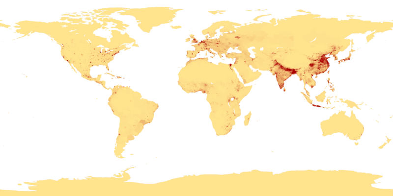
Dencukaay:Population density.png

Dayoob bii wonendi: 800 × 400 pixel. Yeneen ñawaay: 320 × 160 pixel • 640 × 320 pixel • 1 024 × 512 pixel • 1 280 × 640 pixel • 2 560 × 1 280 pixel • 4 320 × 2 160 pixel.
réyal nataal bi ((4 320 × 2 160 pixels, réyaayu file bi : 522 kio, type MIME : image/png))
Jaar-jaaru dencukaay bi
Cuqal cib taariix/waxtu ngir gis ni dencukaay bi meloon ca jamono jooju.
| Taariix ak Waxtu | Tuutal | Dayoo | Jëfandikukat | Saraa | |
|---|---|---|---|---|---|
| teew | 11 Awril 2013 à 00:41 |  | 4 320 × 2 160 (522 kio) | Jahoe | Re-downloaded original from http://eoimages.gsfc.nasa.gov/images/imagerecords/53000/53005/population_density.tif, re-converted to PNG (preserving alpha channel) using tiff2png (by Willem van Schaik and Greg Roelofs). Removed rgb pixel values from fully... |
| 27 Fewriyee 2007 à 03:41 |  | 4 320 × 2 160 (915 kio) | Keenan Pepper | This image shows the number of people per square kilometer around the world in 1994. The data were derived from population records based on political divisions such as states, provinces, and counties. The image was taken from [http://visibleearth.nasa.go |
Xët yi am wii ŋara
Xët wii ci suuf ëmb na wii ŋara
Fépp fees jëfandikoo dencukaay bi
Yeneen wiki yiy toftal dañuy jëfandikoo itam bii dencukaay:
- Jëfandikoo nañu ko ci als.wikipedia.org
- Jëfandikoo nañu ko ci an.wikipedia.org
- Jëfandikoo nañu ko ci ar.wikipedia.org
- Jëfandikoo nañu ko ci ast.wikipedia.org
- Jëfandikoo nañu ko ci az.wikipedia.org
- Jëfandikoo nañu ko ci be-tarask.wikipedia.org
- Jëfandikoo nañu ko ci be.wikipedia.org
- Jëfandikoo nañu ko ci bg.wikipedia.org
- Jëfandikoo nañu ko ci bh.wikipedia.org
- Jëfandikoo nañu ko ci bn.wikipedia.org
- Jëfandikoo nañu ko ci bs.wikipedia.org
- Jëfandikoo nañu ko ci ca.wikipedia.org
- Jëfandikoo nañu ko ci ce.wikipedia.org
- Jëfandikoo nañu ko ci ckb.wikipedia.org
- Jëfandikoo nañu ko ci cu.wikipedia.org
- Jëfandikoo nañu ko ci cv.wikipedia.org
- Jëfandikoo nañu ko ci da.wikipedia.org
- Jëfandikoo nañu ko ci da.wikibooks.org
- Jëfandikoo nañu ko ci de.wikipedia.org
- Jëfandikoo nañu ko ci dsb.wikipedia.org
- Jëfandikoo nañu ko ci el.wikipedia.org
- Jëfandikoo nañu ko ci en.wikipedia.org
- Jëfandikoo nañu ko ci en.wikiquote.org
- Jëfandikoo nañu ko ci eo.wikipedia.org
- Jëfandikoo nañu ko ci es.wikipedia.org
Wone njëfandikoo gu daj gu bii dencukaay.


