
Dencukaay:Location-Europe-UNsubregions, Kosovo as part of Serbia.png

Dayoob bii wonendi: 638 × 599 pixel. Yeneen ñawaay: 256 × 240 pixel • 511 × 480 pixel • 984 × 924 pixel.
réyal nataal bi ((984 × 924 pixels, réyaayu file bi : 50 kio, type MIME : image/png))

|
Une version vectorielle de cette image existe, dans le format « SVG ». Si elle n’est pas inférieure, elle devrait être utilisée à la place de la présente version pour des affichages en plus grandes dimensions ou nécessitant une meilleure résolution.
File:Location-Europe-UNsubregions, Kosovo as part of Serbia.png → File:Europe subregion map UN geoscheme.svg
Pour plus d’informations sur les images vectorielles, consultez la page de transition de Commons vers le format SVG. Voir aussi les informations à propos de la manière dont le logiciel MediaWiki gère les images au format SVG. |
 |

|
This map has been uploaded by Electionworld from en.wikipedia.org to enable the |
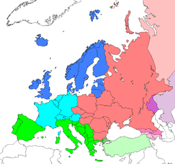
Map: Europe (location), subregions as delineated by United Nations geographic classification scheme:
- Asian portions of these countries
- Asian portions of these countries
Countries of Central Asia with partial territory in Eastern Europe – Kazakhstan
- Asian portions of these countries
Anami Jëfandikoo gi
| Cette œuvre a été placée dans le domaine public par son auteur, Electionworld. Ceci s’applique dans le monde entier. Dans certains pays, ceci peut ne pas être possible ; dans ce cas : |
Journal des téléversements d’origine
| date/time | username | resolution | size | edit summary |
|---|---|---|---|---|
| 16:25, 10 June 2008 | User:Milosevo | 984×924 | 50 KB | STOP VANDALISING! KOSOVO ISN'T A UN MEMBER, SO KOSOVO CAN'T BE IN A UN SUBREGION! |
| 13:28, 10 June 2008 | User:Cradel | 638×599 | 166 KB | Reverted to version as of 20:44, 9 June 2008jere |
| 12:07, 10 June 2008 | User:Milosevo | 984×924 | 50 KB | Reverted, again: kosovo isn't UN member, so it can't be in an UN subregion. |
| 20:44, 9 June 2008 | User:Cradel | 638×599 | 166 KB | Reverted to version as of 20:16, 8 June 2008 |
| 14:15, 9 June 2008 | User:Milosevo | 984×924 | 50 KB | kosovo isn't a UN member, so it can't be in an UN subregion. |
| 20:16, 8 June 2008 | User:Cradel | 638×599 | 166 KB | Reverted to version as of 18:17, 1 May 2008 |
| 10:17, 8 June 2008 | User:Milosevo | 984×924 | 50 KB | Reverted to version as of 23:06, 30 April 2008 |
| 18:17, 1 May 2008 | User:Cradel | 638×599 | 166 KB | Reverted vandalism |
| 23:06, 30 April 2008 | User:Serbish | 984×924 | 50 KB | Reverted to version as of 23:01, 29 January 2008 |
| 20:53, 7 April 2008 | User:Cradel | 638×599 | 166 KB | + Kosovo |
| 23:01, 29 January 2008 | User:Mahahahaneapneap | 984×924 | 50 KB | pngcrushed |
| 14:46, 3 December 2006 | User:Electionworld | 984×924 | 73 KB | {{ew|en|Cogito ergo sumo}} Map: <a href="/wiki/Europe" class="mw-redirect" title="Europe">Europe</a> (location), <a href="/w/index.php?title=Subregion&action=edit&redlink=1" class="new" title="Subregion (page does not exist)">subregions</a> as delineated by [http://unstats.un.org/unsd/methods/m49/m49regin.htm United Nations geographic classification scheme]:<br> {{legend|#4080FF|<a href="/w/index.php?title=Northern_Europe&action=edit&redlink=1" class="new" title="Northern Europe (page does not exist)">Northern Europe</a>}} {{legend|#00FFFF|[[Wes |
Jaar-jaaru dencukaay bi
Cuqal cib taariix/waxtu ngir gis ni dencukaay bi meloon ca jamono jooju.
| Taariix ak Waxtu | Tuutal | Dayoo | Jëfandikukat | Saraa | |
|---|---|---|---|---|---|
| teew | 8 Ut 2008 à 15:17 | | 984 × 924 (50 kio) | BetacommandBot | move approved by: User:Samulili This image was moved from Image:Location-Europe-UNsubregions.png {{ew|en|Cogito ergo sumo}} Map: Europe (location), subregions as delineated by [http://unstats.un.org/unsd/methods/m49/m49regin.htm United |
Xët yi am wii ŋara
Xët wii ci suuf ëmb na wii ŋara
Fépp fees jëfandikoo dencukaay bi
Yeneen wiki yiy toftal dañuy jëfandikoo itam bii dencukaay:
- Jëfandikoo nañu ko ci ace.wikipedia.org
- Jëfandikoo nañu ko ci af.wikipedia.org
- Jëfandikoo nañu ko ci ar.wikipedia.org
- Jëfandikoo nañu ko ci be-tarask.wikipedia.org
- Jëfandikoo nañu ko ci be.wikipedia.org
- Jëfandikoo nañu ko ci bg.wikipedia.org
- Jëfandikoo nañu ko ci bn.wikipedia.org
- Jëfandikoo nañu ko ci br.wikipedia.org
- Jëfandikoo nañu ko ci bs.wikipedia.org
- Jëfandikoo nañu ko ci ceb.wikipedia.org
- Jëfandikoo nañu ko ci crh.wikipedia.org
- Jëfandikoo nañu ko ci cy.wikipedia.org
- Jëfandikoo nañu ko ci da.wikipedia.org
- Jëfandikoo nañu ko ci en.wikipedia.org
- Jëfandikoo nañu ko ci en.wikivoyage.org
- Jëfandikoo nañu ko ci eo.wikipedia.org
- Jëfandikoo nañu ko ci eu.wikipedia.org
- Jëfandikoo nañu ko ci fa.wikipedia.org
- Jëfandikoo nañu ko ci fi.wikipedia.org
- Jëfandikoo nañu ko ci fr.wikipedia.org
- Jëfandikoo nañu ko ci fy.wikipedia.org
- Jëfandikoo nañu ko ci fy.wiktionary.org
- Jëfandikoo nañu ko ci gag.wikipedia.org
- Jëfandikoo nañu ko ci gd.wikipedia.org
- Jëfandikoo nañu ko ci gl.wikipedia.org
- Jëfandikoo nañu ko ci id.wikipedia.org
- Jëfandikoo nañu ko ci io.wikipedia.org
Wone njëfandikoo gu daj gu bii dencukaay.