
Dencukaay:Georgia topographic map-fr.svg

Taille de cet aperçu PNG pour ce fichier SVG : 707 × 385 pixel. Yeneen ñawaay: 320 × 174 pixel • 640 × 349 pixel • 1 024 × 558 pixel • 1 280 × 697 pixel • 2 560 × 1 394 pixel.
réyal nataal bi (Dencukaay SVG, kem bu jaadu 707 × 385 pixel, dayoo dencukaay bi: 3,52 Mio)
Faramfacce
| Faramfacce |
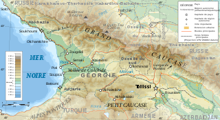
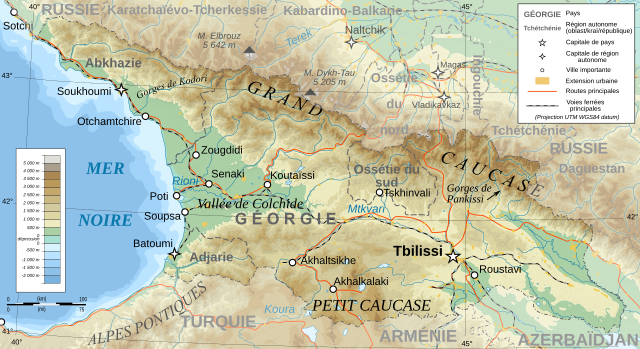
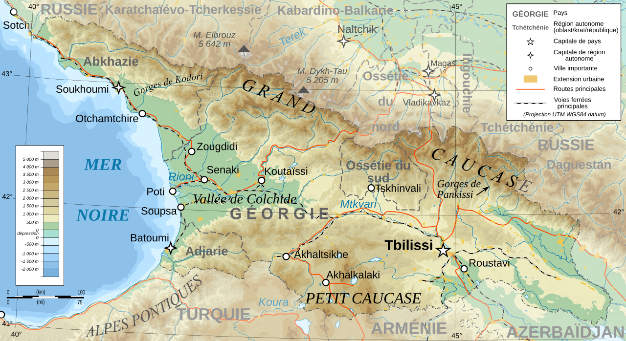
Deutsch: Topographische Karte von Georgien, französische Version English: Topographic map in French of Georgia Français : Carte topographique en français de la Géorgie |
| Taariix | |
| Gongikuwaay |
English: Own work ; Topographic data from the NASA Shuttle Radar Topography Mission (SRTM3 v.2) (public domain) edited with 3DEM, reprojected in UTM with GDAL (GDAL), and vectorized with Inkscape ; UTM projection ; WGS84 datum ; shaded relief (composite image of N-W, W and N lightning positions) ; Reference used for the additional data : * Rivers, cities, railroads, routes, bathymetry : Demis add-on for World Wind (see the approval e-mail and the Demis forum) ; * Borders and coast : World data bank II ; Approximate scale of topographic data : 1:1,463,000 ; Note : The shaded relief is a raster image embedded in the SVG file. Français : Création personnelle ; Données topographiques de la NASA Shuttle Radar Topography Mission (SRTM3 v.2) (domaine public) éditées avec 3DEM, reprojetées en UTM avec GDAL et vectorisées avec Inkscape ; projection UTM ; WGS84 datum ; relief ombré (image composite d'éclairages du N-O, O et N) ; Références utilisées pour les données complémentaires : * Rivières, villes, chemins de fers, routes, bathymétrie : Demis add-on for World Wind (cf. l'e-mail d'approbation de Demis et le Demis forum) ; * Frontières et côtes : World data bank II ; Échelle approximative des données topographiques : 1:1 463 000 ; Note : Le relief ombré est une image bitmap embarquée dans le fichier SVG. |
| Aji-jëf | Bourrichon - fr:Bourrichon |
| Sañal (Njëfandikoowaatu bii dencukaay) |
GFDL / Attribution and Share-Alike required |
| Autres versions |
Œuvres dérivées de ce fichier : Georgia topographic map-blanked.svg
|


|
Ce fichier SVG contient du texte encapsulé pouvant facilement être traduit dans votre langue en utilisant n'importe quel éditeur de fichier SVG ou de texte, ou par l'outil de traduction de fichiers SVG. Pour plus d'informations, voir : A propos de la traduction des fichiers SVG. |
Anami Jëfandikoo gi
Moi, en tant que détenteur des droits d’auteur sur cette œuvre, je la publie sous les licences suivantes :

|
Sañalees na duppi, séddale ak/walla soppi bile liggéey ci anami GNU Free Documentation License, Sumb 1.2 walla bépp sumb buFree Software Foundation mujjee siiwal; bu amul benn pàcc bees manul soppi, te amul it menn mbind ci xët wu njëkk week wu mujj wi. Ab sotti bu sañal gi jàppandi na ci pàcc bees duppee GNU Free Documentation License. |
This file is licensed under the Creative Commons Attribution-Share Alike 4.0 International, 3.0 Unported, 2.5 Generic, 2.0 Generic and 1.0 Generic license.
- Féeg nga ci:
- séddoo – duppi, séddale ak yónnee bile liggéey.
- soppi – soppi liggéey bi
- Ci kaw yii anam:
- Moomale – Fàww nga joxe ay xibaar yu leer ñeel boroom, joxe ab lëkkalekaay buy jëme ci sañal gi te wax ndax def nga ciy coppite. Man nga koo def ci anam yu bari, ba mu des ci guy wund ne aji-moom ji dafa ànd ak yaw walla ànd na ci ninga koy jëfandikoo)
- Séeddoo ci gii anamam – Soo soppee walla nga defar leneen te sukkadiku ci bii liggéey, faww nga siiwal ko ci genn sañal gi walla geneen gum méngool
Man ngaa tànn sañale gi la gënal.
Jaar-jaaru dencukaay bi
Cuqal cib taariix/waxtu ngir gis ni dencukaay bi meloon ca jamono jooju.
| Taariix ak Waxtu | Tuutal | Dayoo | Jëfandikukat | Saraa | |
|---|---|---|---|---|---|
| teew | 13 Samwiyee 2020 à 14:57 | | 707 × 385 (3,52 Mio) | Takhirgeran Umar | clarification |
| 30 Maars 2009 à 21:43 |  | 707 × 385 (3,52 Mio) | Bourrichon | +Daguestan | |
| 13 Maars 2009 à 18:09 |  | 707 × 385 (3,52 Mio) | Bourrichon | + longitude | |
| 13 Maars 2009 à 18:01 |  | 707 × 385 (3,52 Mio) | Bourrichon | -Iran | |
| 13 Maars 2009 à 17:38 |  | 707 × 385 (4,55 Mio) | Bourrichon | + Gorges | |
| 13 Maars 2009 à 17:32 |  | 707 × 385 (4,52 Mio) | Bourrichon | == Summary == {{Information |Description={{de|Topographische Karte von Georgien, französische Version}}{{en|Topographic map in French of Georgia}}{{fr|Carte topographique en français de la [[:fr:Géorgie (pays)|Géorgie] |
Xët yi am wii ŋara
Xët wii ci suuf ëmb na wii ŋara
Fépp fees jëfandikoo dencukaay bi
Yeneen wiki yiy toftal dañuy jëfandikoo itam bii dencukaay:
- Jëfandikoo nañu ko ci ab.wikipedia.org
- Jëfandikoo nañu ko ci cv.wikipedia.org
- Jëfandikoo nañu ko ci fr.wikipedia.org
- Géorgie (pays)
- Géographie de la Géorgie
- Projet:Cartographie/Cartes standards/Pays
- Wikipédia:Atelier graphique/Cartes/Archives/mars 2009
- Wikipédia:Atelier graphique/Cartes/Archives/avril 2009
- Wikipédia:Atelier graphique/Cartes/Archives/Demandes mises en sommeil/Europe
- Liste des villes jumelées de Géorgie
- Jëfandikoo nañu ko ci ht.wikipedia.org
- Jëfandikoo nañu ko ci uz.wikipedia.org